Saturday, July 14, 2012

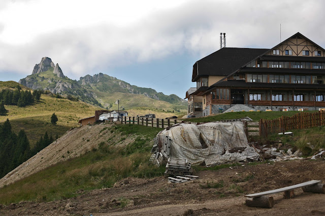
Destroyed forest in Ciucaş Mountains, Romania


The Ciucaş Mountains are a mountain range in Romania, part of the Curvature Carpathians. The highest peak is Vârful Ciucaş (Ciucaş Peak) and it measures 1,954 meters. (wikipedia)
The Ciucaş Mountains are famed for the spectacular rocky formations known as “Tigăile Mari” and “Tigăile Mici” (Big and Small Pans) , “Turnul lui Goliat” (Goliat’s Tower), “Colții Bratocei” (The Bratocei Fangs) or “Mâna Dracului” (Devil’s Hand).
The Ciucaş Mountains host a natural reservation with a ruiniform relief and a rich vegetation which consists of grazing, brushwood and rocky plants. Also, the Ciucaş Mountains are the natural habitat for wild animals such as bear, wild boar, deer, fox, lynx, marten, squirrel, black goat, birds – eagle, golden eagle, hawk, nightingale, chaffinch, or reptiles as: adder (Vipera berus) and lizard (Lacerta vivipara). (wikipedia)

Beginning with the year 2008, the forest in the Western part of the Ciucaş Mountains was cut in half by a road witch leads to a new refurbished hotel named “Ciucaş Peak Chalet“. The hotel replaces an old chalet, named “Alexandru Vlahuță”, which burned years ago. This forestry road starts from the 1A Highway through the “Valea Berii” (Beer Valley) and reaches the hotel. The road is open to all cars which makes a high rank of pollution in the mountains. By entering so deep in the heart of the mountains, the impact of the road on fauna and flora is high and endangers the natural habitat and the species.


Thursday, July 12, 2012

Goats at Green Mountain

Goats rest on a Green Mountain's terrace (Green Rock) near Slanic Prahova, Romania. The volcanic rock formations are the result of strengthening of the volcanic ashes over the years and they are geologically disposed in layers with perfect plane surfaces. The mountain gets a green color every time it rains.

Monday, June 18, 2012

Racos Geological Complex, Romania


In 2005, the Racos Geological Complex was declared natural protected area and it represents a natural geological reservation with a national importance. (ospbaraolt.webs.com) 
It is situated in the Western part of Persani Mountains, close to the basalt stripping in Racos village, Brasov region.
The area, included in Natura 2000 - Dealurile Homorodului site, is spread on a surface of over 95 hectare and is rich in volcanic rocks and mineral springs. Racos Geological Complex consist of tree quarry – two former basalt stripping and one for excavation of the basaltic slag. Even though the area is declared protected there are still excavations in the basaltic quarry, limestone quarry, or ballast pit, and the locals steal the rocks with the carriage.


The volcanic cone is located on Heghes Hill and it’s known as the Cariera de scorie vulcanică „Dealul Hegheş” ( The quarry of basaltic slag “Heghes Hill”). (brasovultau.ro) 
For many years, slag was excavated from the volcano cone. In the meantime, the area became natural reservation and the excavations were stopped. The highest point of the complex is the Heghes peak, measuring 60 meters.

Ten years ago, after the suspension of the basalt excavations in Brazi Quarry, a lake was formed as a result of snow melting and accumulation of rain water. The lake measures 10 meters in depth and 100 meters in length.

The natural monument Coloanele de bazalt de la Racoş (Racos basalt pillars) is included in the Racos Geological Complex. The basalt pillars measure 15 meters in height and were formed by the cooling of volcanic lava. The last volcanic eruption in the Carpathian Mountains occurred 800 thousand years ago, so the Racos Geological Complex  contains the newest rocks found in Carpathians. (adevarul.ro)


Agarak Copper-Molybdenum Mine Complex, Armenia


The Agarak Copper-Molybdenum Mine Complex was originally established in 1958, and is an open-pit copper-molybdenum deposit located in the Syunik province of Armenia.
Situated near to the town of Meghri, the Agarak Copper-Molybdenum Mine Complex looks like a massive wound inside the mountains. Also, it is an important polluter for the villages around and for the Arevik National Park.
The roads of this mine complex are frequently used by the locals as shortcuts between villages.

Friday, June 15, 2012

Abandoned natural resources in Balvanyos, Romania

Cetăţile Păgânilor (Pagan Citadels, Hungarian Bálványos) is a spa resort in Covasna County, situated in Eastern Transylvania, central Romania. It lies at an altitude of almost 800 m on the southern slopes of the Bodoc Mountains, 67 km from Sfântu Gheorghe.
The place is known for it’s hydrothermal and post volcanic phenomenon still active the region. A geological feature is the presence of the mineral springs and the mofette - volcanic discharge consisting chiefly of carbon dioxide, often associated with other vapors, representing the final phase of volcanic activity. The volcanic vents yielding the emanations are themselves called mofette. Depending of the mineral content of the different vapors, mofette can be used for therapeutic purposes. As carbon dioxide is heavier than the air, patients can use it as dry spa, if certain safety regulations are complied with.
The therapeutic properties of the Balvanyos mineral springs and dry spa are known from ancient times, but the exploitation of the resources started in 1938. The Balvanyos spa is formed by merger of three spa colonies and the oldest one is the Puciosa din Turia ( The Sulfurous from Turia), an artificial sulfurous mine that emanates daily a big quantity of gas (CO2, H2S and others), approx. 3000 m3 (~2 m3/sec). (wiki)
Today, most of these “golden” natural resources are abandoned and destroyed but despite this fact, people are still visiting them. 

...and a fox looking for a "meal" in a barbecue area near to the village Turia.